


De Panne

JanBekaert
User
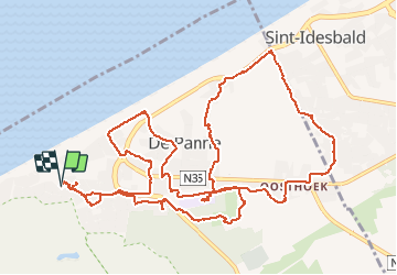

Length
15.2 km

Max alt
19 m

Uphill gradient
76 m
Km-Effort
16.3 km

Min alt
4 m

Downhill gradient
76 m
Boucle
Yes
Creation date :
2016-05-22 00:00:00.0
Updated on :
2016-05-22 00:00:00.0
4h13
Difficulty : Easy

FREE GPS app for hiking
 SityTrail
IGN / Geographical institutes
SityTrail Plus
The world is yours!
About
Trail Walking of 15.2 km to be discovered at Flanders, West Flanders, De Panne. This trail is proposed by JanBekaert.
Description
duinen
Photos


Positioning
Country:
Belgium
Region :
Flanders
Department/Province :
West Flanders
Municipality :
De Panne
Location:
De Panne
Start:(Dec)
Start:(UTM)
470115 ; 5660432 (31U) N.
Comments